

Why drives and generic file links break down on LiDAR jobs
Couriered hard drives and generic shared folders solve raw byte transfer, not survey review. A client opens a folder of LAS or LAZ tiles and immediately asks which files to load, which coordinate system applies, or whether yesterday’s link still points to the latest revision.
When you send a replacement file over email or overwrite a shared drive folder, there is no numbered release history and no record showing which version the receiving team opened or downloaded.
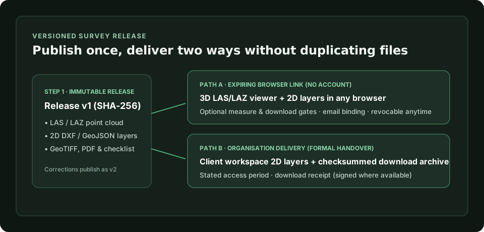
Scroll sideways to see the whole diagram
Deliver processed LAS and LAZ files instead of raw flight archives
Keep raw multi-terabyte sensor captures in your own field archive and publish the cleaned, classified LAS or LAZ deliverables that stakeholders actually review. GISweaver reads compressed LAZ directly without asking you to decompress it to LAS first, up to your plan’s maximum file size.
See supported formats and file behaviour
What opens in 3D by link vs in an organisation delivery
Choosing between an expiring browser link and a formal organisation-to-organisation delivery depends on whether the recipient needs quick visual inspection or a structured archive transfer:
| Capability | Expiring browser link | Organisation delivery |
|---|---|---|
| Account required | None (opens straight in browser) | Client signs in to own organisation |
| Point clouds (LAS / LAZ) | Opens in 3D in the browser | Delivered as checksummed project files |
| 2D map layers | GeoJSON, ASCII DXF, KML, KMZ, GPKG, zipped SHP | GeoJSON, ASCII DXF, KML, KMZ, GPKG, zipped SHP |
| Download & measure controls | Sender chooses per link; email-bindable and revocable | Access period, hold window, download receipt (signed where available) |
Compare link and organisation delivery
Try a sample point cloud in the browser before uploading
If you want to see how a LAS point cloud and 2D survey layers behave for an external client before creating an organisation, open the sample survey in the GISweaver Playground with no account.